By: Andy Extance
Send to a friend
The details you provide on this page will not be used to send unsolicited email, and will not be sold to a 3rd party. See privacy policy.
An international collaboration of space agencies that provides free satellite imagery and data to assist disaster responses is now supporting efforts to control the Ebola virus outbreak in West Africa.
When the International Charter on Space and Major Disasters was activated on 9 October it was the first time it had been triggered in response to a disease outbreak.
The charter has previously only been activated to help map areas in response to natural disasters such as typhoons.
In the Ebola context, satellite data could assist attempts to find out where the virus originated and help produce maps useful for coordinating medical responses.
Efforts on both these fronts had already begun prior to the activation, but Audrey Lessard-Fontaine, a GIS (geographic information system) specialist with medical charity Médecins Sans Frontières (MSF), is optimistic that the charter activation can supplement these.
“For sure governments in the region would be interested in having access to satellite imagery to help their response,” she says.
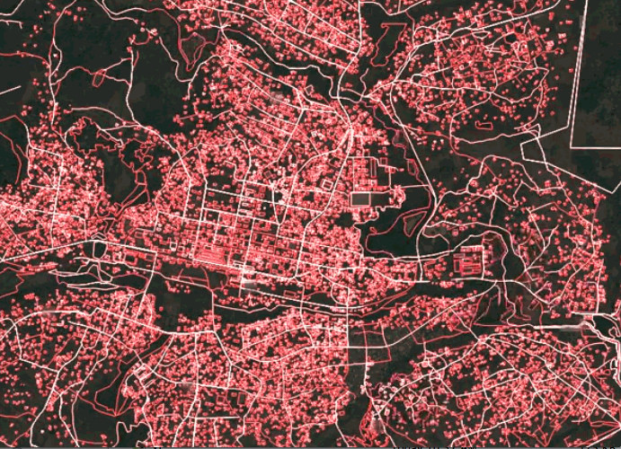
In March MSF made satellite imagery of Guinea, which it had purchased, available to open-data mapping initiative OpenStreetMap. With the help of 244 volunteers, the town where the outbreak was first recognised, Guéckédou, and neighbouring towns Macenta and Kissidougou, were mapped in less than three days. These maps helped MSF track the spread of the disease and plan their response, says Lessard-Fontaine.
The charter activation could help initiatives such as this and other mapping organisations and initiatives involved in the struggle to halt the outbreak.
For example, MapAction, an NGO that provides maps in the aftermath of disasters, has been supporting the UN Disaster Assessment and Coordination team that went to Liberia on 19 September. Satellite imagery can help create maps to make sense of limited existing information, says Matt Sims, MapAction’s deployments coordinator.
MapAction regularly presses for the charter to be activated as soon as possible in disasters such as floods. Sims says that LISGIS (Liberia Institute of Statistics and Geo-Information Services) and the US Department of Defense, which is helping to build Ebola treatment units (ETUs) in the country, could now exploit the resulting data.
“Satellite imagery is going to be used in planning for ETUs and also identifying helicopter landing zones,” Sims explains.
The initial imagery the Department of Defense used was many years old, Sims says. So although plenty of potential landing sites were identified, when people got there they found they were now overgrown jungle, he says.
And Copernicus, an Earth monitoring system run by the European Commission, has been working with MSF to integrate satellite data with virtual mapping program Google Earth to study palm tree densities. The main vectors of the virus are bats, which live in oil palms, and so identifying areas of oil palm cultivation helped MSF locate potential patients early on.
Such efforts are where the charter data are most likely to be used, according to Robert Meisner, a communication programme officer from the European Space Agency, one of the charter partners. “The bats live in small palm oil plantations scattered around little villages,” he explains. “Normally it’s difficult to identify them because they’re surrounded by other trees, but our data can help with that.”


