


02/09/26
Nepal flood disaster exposes cascading threats in Himalayas
By: Tauseef Ahmad and Sajid Raina
Send to a friend
The details you provide on this page will not be used to send unsolicited email, and will not be sold to a 3rd party. See privacy policy.
[KATHMANDU, Nepal, SciDev.Net]: A catastrophic flood in Nepal that left thousands missing started with a collapse of ice and rock high in the mountains—a warning that disaster planning must prepare for chains of hazards, not isolated events, say experts.
The cascade of ice, rock and debris that tumbled through the Nepal-China border region last week probably blocked a tributary of the Bhotekoshi river, forming a dam, before bursting downstream with devastating force, according to disaster analysis.
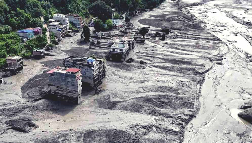
The torrent arrived in Nepal’s Rasuwa district with little warning, ripping through settlements along the Bhotekoshi river system, destroying bridges, roads and hydropower infrastructure and cutting a vital trade route with Tibet.
More than 1,000 people have been confirmed dead, with almost 4,000 still missing and around 11,800 rescued, according to UN figures on Tuesday (1 September). Thousands are in need of humanitarian assistance, hindered by blocked roads and damaged bridges.
Experts say the disaster illustrates a growing problem across the Hindu Kush Himalaya: hazards that once might have been assessed separately—glacier collapse, landslides, avalanches, river blockages, floods and even earthquakes—can interact within minutes or hours, creating an event that is much larger than any one of them.

“Most people think of flash floods as being caused by heavy rainfall,” said Liz Stephens, professor of climate risks and resilience at the University of Reading, in the UK.
But in high mountain regions such floods can result from “complex chains of hazards, including landslides, avalanches and glacial lake outburst floods”, she added.
That complexity, says Stephens, makes early warning particularly difficult.
Tributary blocked
Analysis of satellite imagery from US aerospace and data analytics company Planet Labs suggests that a substantial section of glacier and surrounding rock collapsed at high altitude near the Nepal-China border, sending an enormous mass of ice, snow and debris towards the valley.
The collapse appears to have affected the Lhende Khola, a tributary that becomes part of the Bhotekoshi river system.
A rapid-analysis report released by the Integrated Research on Disaster Risk (IRDR) on Friday (28 August) said the event was likely caused by an “ice, rock and soil mass failure” rather than intense rainfall.
The material probably blocked the river for about 18 or 19 hours, forming a natural dam which then gave way on the morning of 26 August, unleashing masses of water, ice, rocks and sediment, the report said.
Funnelled by the steep Himalayan terrain, the surge became a fast-moving mixture of water and debris capable of carrying huge boulders, destroying bridges and erasing riverbanks.
The rapid-analysis report said the steep gradient and narrow valley accelerated and concentrated the flow, while the heavy debris load increased its destructive power.
Chinese state broadcaster CCTV said the flood was “caused by glacier instability under the long-term effects of global warming” and described this as a “new and prominent feature of cryosphere disasters” on the Tibetan plateau.

A view of Everest region with glaciers and loose rocks in Nepal. Falling ice, rock and debris likely triggered flash flood in the country. Credit: UN Photo/Narendra Shrestha
‘Bigger than the atom bomb’
Experts say these findings highlight the need for change in disaster monitoring.
A conventional flood warning system may detect rising rainfall or river levels. But a cascading cryospheric event can begin kilometres away, and at much higher elevation, with no obvious warning for communities downstream.
The International Centre for Integrated Mountain Development (ICIMOD) argues that disaster planning in the region needs to move away from treating hazards independently.
“With the nature of disaster risks rapidly mutating in the region, disaster risk reduction strategies can no longer evaluate hazards in isolation,” Saswata Sanyal, a disaster-risk reduction specialist at ICIMOD, told SciDev.Net.
“The era of preparing for a single, predictable hazard is over.”
The disaster comes just over a year after another major flood affected the same Lhende Khola-Bhotekoshi system.
In July 2025, flooding in the area was linked by Nepalese authorities to a glacial lake outburst. The recurrence is raising questions about whether the river corridor is becoming a particularly exposed pathway for cryosphere-related hazards.
A 2026 ICIMOD assessment found that glaciers across the Hindu Kush Himalaya lost about 12 per cent of their area between 1990 and 2020, and the rate of ice loss has doubled since 2000.
As glaciers retreat, new lakes can form, slopes can lose the support provided by ice, and frozen ground can become unstable. A glacier collapse can then entrain rock and soil, turning an initial ice avalanche into a debris flow capable of travelling tens of kilometres.
Research published in April on Himalayan hanging glaciers found that rising temperatures and shifting regional precipitation patterns are reducing glacier stability and increasing the risk of ice avalanches. The authors identified more than 219 hanging glaciers in northern India’s Alaknanda basin and warned that break-offs can cause physical damage and trigger secondary hazards, including glacial lake outburst floods.
A separate study on ice-rock avalanches in the Himalayas similarly concluded that such failures can rapidly transform into high-velocity debris flows, while stressing the difficulty of identifying precursors, or warning signs.
Geohazard expert Basanta Raj Adhikari, director of Tribhuvan University’s Centre for Disaster Studies, in Nepal, described the 26 August flood as an unprecedented event in the region.
“In my research career, I haven’t seen a bigger flood event than this in the Himalayan landscape,” Adhikari said, attributing its extraordinary force to the enormous volume of ice and debris that descended from the mountains.
“I calculated the amount of energy, which is bigger than the atom bomb that happened in Hiroshima,” he added.
He said the scale of the event demonstrates the immense destructive potential of cascading ice, rock and water hazards in the Himalayas.
Neighbours at risk
The disaster also raises questions about disaster preparedness in the wider region.
The Hindu Kush Himalaya stretches across Afghanistan, Pakistan, India, Bhutan, Bangladesh, and Myanmar, as well as Nepal and the Tibetan plateau, connecting communities through river systems that cross political boundaries.
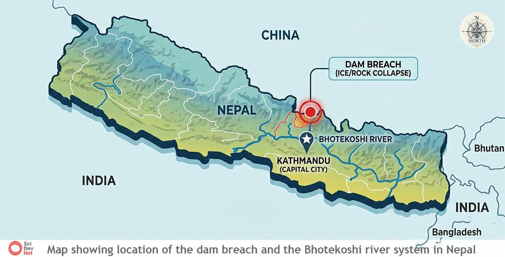
This infographic was designed using AI.
In India, the 2021 Chamoli disaster demonstrated the destructive potential of a similar ice-rock cascade. A massive collapse in Uttarakhand sent water, ice and debris through the Rishiganga valley, killing more than 200 people and destroying hydropower facilities.
Scientists are increasingly treating such events as compound hazards rather than isolated disasters.
Across Bhutan and Nepal, glacial lakes are being monitored for possible outburst floods. In Pakistan, rapidly changing glaciers and high-mountain valleys create a complex combination of flood, landslide and avalanche risks.
A recent UNDP assessment of human security in the Hindu Kush Himalaya warned that climate impacts can cascade across interconnected food, water and energy systems, creating compound threats that are greater than individual hazards considered separately.
Satellite warnings
Experts say the Rasuwa disaster also provides a powerful demonstration of the potential—and limits—of satellite technology.

Images shown above were captured by the Copernicus Sentinel-2 mission showing the Nepal glacier collapse and flood before and after (24/27 August 2026). Source: ESA (CC BY 4.0 INT(opens in new tab)).
Satellite images helped scientists reconstruct what happened in an otherwise extremely difficult-to-access area. High-resolution imagery can reveal changes in glacier geometry, newly formed lakes, landslide scars, blocked rivers and altered drainage channels.
In the aftermath of the flood, authorities have used satellite observations to monitor newly formed lakes upstream that could pose additional risks if their natural barriers fail.
But identifying a disaster after it happens is very different from predicting it beforehand.
Ishfaq Ahmad, a satellite scientist based in Nepal, told SciDev.Net that while scientists can identify and assess potentially dangerous glacial lakes using satellite imagery and visual observations, predicting the exact moment when a lake will burst remains a challenge.
“Glacial lakes can be seen with our eyes and through satellite data. We can assess whether the lakes are potentially dangerous or not,” Ishfaq said.
But he said sudden triggers, such as rockfalls or ice collapses, can occur too rapidly for orbiting satellites to detect them in advance.
Satellites do not continuously observe every Himalayan slope at the resolutions needed to reliably detect an imminent collapse. Clouds can obscure optical imagery, while revisit times can leave gaps between useful observations.
Ground sensors can provide continuous measurements but installing and maintaining them is challenging in remote, high-altitude terrain, where field observations remain sparse.
The answer, therefore, is unlikely to be a single technology.
Scientists increasingly argue for combining satellite imagery with seismic sensors, river gauges, automated cameras, weather forecasts, glacier monitoring and local community warning networks.
ICIMOD has noted that only a fraction of Himalayan glaciers are adequately monitored, leaving large areas as blind spots. It has called for better data and for scientific information to be translated into decisions that communities can act on.
This piece was produced by SciDev.Net’s Global desk.