08/01/20

Australian bushfire smoke drifts to South America

incendios Australia AL foto ppal.jpg
Meteorological satellites captured the movement of a smoke cloud coming from Australia’s bushfires. Copyright: Goes 16 Cirarrammb / Inumet satellite image

Speed read

  • Brazil, Argentina, Chile and Uruguay have detected smoke from fires in Australia
  • Experts say there is no risk to health or aviation but urge vigilance
  • Colombian scientists create a model to predict future fires

Send to a friend

The details you provide on this page will not be used to send unsolicited email, and will not be sold to a 3rd party. See privacy policy.

Smoke particles from the fires ravaging Australia have traveled more than 12,000 km, crossed an ocean and a mountain range and arrived in South America, meteorological institutions confirmed, after smoke was detected in Chile, Argentina, Brazil and Uruguay.

“From the afternoon of 6 January, a grey cloud and redder sunrises and sunsets could be seen in the sky [in Uruguay] due to the presence of small particles in suspension, more than 6,000 meters high, of smoke generated by the great fires in Australia,” said a statement from the Uruguayan Institute of Meteorology (Inumet).

Lucia Chiponelli, technical manager at Inumet, told SciDev.Net that despite the annual “bushfire season” in Australia, this was the first time smoke had been recorded arriving in Latin America in recent decades.

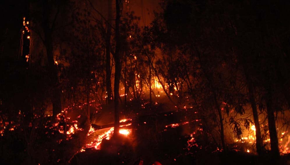
Fires raging in Australia since September have killed 24 people, destroyed more than 1,500 homes, and razed 6 million hectares of land, leaving more than 500 million animals dead. The bushfires, which are among the worst in the country’s history, have been fuelled by record temperatures — 41.9 °C on 17 December — and several months of intense droughts.

It comes after record fires in the Brazilian Amazon last year burned around 1 million hectares of forest between July and September, according to official statistics, while environmental organisations put the figure at more than double that.

NASA video shows the movement towards South America of a huge cloud of smoke from the Australian fires.

One of the consequences of such fires is that when air is heated it rises to the upper layers of the atmosphere, dragging particles from the burned materials along with carbon monoxide and other compounds derived from combustion.

 
This hot air reaches a height of up to 6,000 meters and from there joins the air currents of the Southern Hemisphere, Chiponelli explained. Smoke from Australia entered Latin America through Chile “because air circulation [in the Southern Hemisphere] always goes from west to east,” Soledad Osores, of the National Meteorological Service of Argentina, told SciDev.Net.
 

From Chile to Uruguay

On 6 January, the Chilean Meteorological Directorate announced the presence of smoke whose “effect was seen in the sun with red tones (…) the product of a cloud of smoke coming from the [Australian] fires”.
 
In Argentina, the smoke was visible to the naked eye from Patagonia, in the south of the country, to Santiago del Estero, in the north. The greatest concentrations were found at about 5,000 metres high, and therefore had no impact on surface visibility, according to the meteorological service. "It's just smoke, without ash, that will dim sunlight during daylight hours," Osores added.
 
In Uruguay, smoke arrived 6 January, as was the case in southern Brazil. "The sky was grey in several cities west and south of Rio Grande do Sul [Brazil’s southernmost state]. In the cities of the northern half of the state, including Porto Alegre, smoke was not noticed due to the large number of clouds," a spokesman for the Brazilian meteorological company MetSul told SciDev.Net.
 
MetSul added that with smoke remaining in the Pacific, more particles could be expected to arrive in Brazil in the weeks ahead, depending on wind currents.
 

However, the situation depends on many factors. Even if Australia’s fires persist at their current rate, the concentration of particles can be lessened by local circumstances. The smoke reached Latin America more than a month after the fires started in Australia, for example, after being dispersed by Pacific Ocean winds in its path.

Australia night fire

Forest fires raging in Australia since September have destroyed homes, land and wildlife. Credit: Sascha Grant (CC BY-NC-ND 2.0). This photo has been cropped.
 

Other factors, such as storms, may stop the smoke in its tracks. “The clouds that generate storms have a vertical development that can reach 6,000 meters high. If the particles enter those storm clouds they will precipitate with the rain. Then, if storms form on the road over the ocean or when entering Chile, the particles do not arrive,” said Chiponelli.

 
According to Osores, the rains forecast for Wednesday [8 January] and Thursday in Patagonia, in the central area of Argentina, will reduce the particle load towards the end of this week.
 

Health and airplanes

Daniel San Vicente, cardiologist and president of the Montevideo regional council of the Medical College of Uruguay, said the current concentration of particles in the air was not enough to have an impact on health. But he said the episode should alert doctors to the possible health effects of events related to climate change.
 
Another sector potentially affected by such events is aviation, since smoke clouds are found at the same altitude at which aeroplanes fly and particles can reduce visibility. However, both Inumet and MetSul agreed that visibility has not been affected so far.
 
“It is not worrisome [for health or aviation] but you have to be alert. Public and media interest is well-founded, especially since Australia is far away and the arrival of smoke particles helps people to understand the magnitude of the fires that affect that country,” said Chiponelli.
 

How can we predict fires?

The severity of the fires has shone a spotlight on strategies to prevent further outbreaks and deal with the growing climate threat.  
 
Scientists from Medellin, Colombia, gathered at the American Geophysical Union conference in December in San Francisco, to share the results of a fire prediction model that could be expanded to other locations.
 
Experts from SIATA, a science and technology project focused on risk analysis of natural hazards, joined citizens to build an air monitoring network, installing more than 100 low-cost sensors in homes and workplaces. The Medellin region records between 500 and 700 fires every year.They also created a rain monitoring network with 84 stations that report in real time, as well as sensors to monitor the Medellín river and its tributaries, accelerometers for seismic activity, and cameras that monitor cloud changes. 
 
Other technologies used by the team included laser sensors to test air quality, a pyrometer to measure solar radiation reaching the earth’s surface, and a radiometer that measures atmospheric temperature and humidity.
 
Nicolás Velásquez, one of the members of the project linked to the University of Iowa, explained that these tools enabled scientists to build a model that generates hourly vulnerability and risk maps of each area to share with firefighters in the region.
 

Results showed that the areas of greatest risk are within a radius of 2,000 metres of urban areas, a sign that many of the fires are started by local people.