07/04/20
Q&A: Recovering from war with help from space

Send to a friend
The details you provide on this page will not be used to send unsolicited email, and will not be sold to a 3rd party. See privacy policy.
Since the launch of Sputnik 1, satellites have been used to examine our planet from the unique vantage of space. From big scientific finds such as the ozone hole, to daily weather forecasts, space technology has transformed our understanding of Earth’s natural processes.
Images also track humanity’s transformation of landscapes: growing cities, altered waterways and effects of conflict. Improvements in optical and sensing technology, paired with artificial intelligence, mean that today’s satellites are already being leveraged to improve the lives and livelihoods of billions around the world.
In fact, satellite imagery is being used to advance many of the global Sustainable Development Goals (SDGs), says Bertrand Frot, information management specialist with the United Nations Development Programme (UNDP). A 2016 pilot programme to monitor war reconstruction efforts in the ancient city of Timbuktu, Mali, had one clear lesson, according to Frot: “Satellite data is easy. Everything is so visible.”
How did the Mali work inform the UNDP’s decision to invest more deeply in satellite imagery for disaster response, reconstruction and development?
One image is worth 100 pages of a report from the ground.
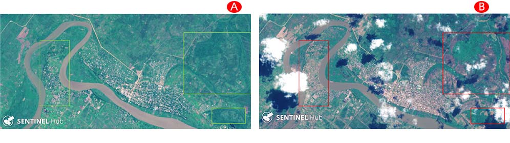
Access to some areas was still difficult — roads were blown out by landmines in many areas. You can see the environmental impact in each of the images — which rivers touch Timbuktu, the progress of reconstruction of buildings and infrastructure, the evolution of the size of the markets. You could also see what was still destroyed.
And in other areas that have been affected by war, we’ve begun to train people on restoring their agriculture and how wars impact the environment. In Iraq, many trees were destroyed, since shooters could hide behind them. So now winds can carry sand more easily from south to north, and it has really changed city landscapes and agriculture. Analysis of historic and current satellite data can show us where to target recuperation efforts, or build new infrastructure to protect crops, or the best areas to develop new croplands.
Are there any SDGs that might particularly benefit from greater use of space technology or AI data processing?
Poverty is the main one. Towards zero hunger, satellite data is being used to evaluate droughts and agricultural yields. Economic growth — the evolution of cities and poverty within cities, as well as how industry and infrastructure are evolving in those places — this is directly related to the SDG to reduce inequality: images can be used to evaluate the evolution of rural and urbanized areas, where in many cases the slums are really visible.
Climate action, most certainly. The Space Climate Observatory provides open-source data and allows for large international studies of the impacts of climate change on a global scale.
One area your office says satellite imagery can help with is getting resources to those who need it most. How does that actually work?
We’ve used this type of analysis in cities like Casablanca, Cairo, Djibouti and in Nigeria. It helps with the planning and evolution of public services.
In Nigeria, we were able to correlate the evolution of some cities with interviews done with migrants who had arrived in Europe from these areas. And then we could take that information to the local Nigerian authorities and say: your area is a large source of migration. Which can help them plan the extensions of their cities and its services more effectively.
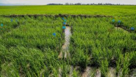
Your office has also done work in Indonesia, exploring floods and their effects on rice cultivation. How does this knowledge translate into action for farmers?
This relates to impacts from climate change. There are some areas where there is less rain over the year, but more concentrated rainfall events that flood the rivers more often than before. Here, satellite data was helpful in seeing the impact of the floods on the supply chain. If silos and warehouses are located in flood zones, or their access roads are inundated, the rice can’t be moved. So these data help in repositioning roads and bridges, or for locating structures to protect the crops.
In Kenya, there are some areas that are regularly flooded, and in some areas new roads can be built to use as a barrier to protect from floods. The imagery helps evaluate whether those barriers are effective.
Are there any environmental projects that have benefited from higher-resolution satellite data?
In South America, we are working in some countries on deforestation, to monitor primary and secondary forest. The idea is to better protect biodiversity by working back towards a more complete landscape.
In Uganda, wetland restoration efforts are being monitored with satellites, as well as the water quality changes that result, and correlating those changes with livelihood indicators. That project has impacted more than 4 million people, and part of it is moving farmers away from damaging crops.
Is there a danger of overpromising on what satellite data can deliver?
The real stakes are in how to scale this up, and turn this into an industrial vision. We didn’t cover the planet with satellites for nothing. So here’s where artificial intelligence can really be leveraged: to help us evaluate under which conditions a solution has worked, and how, if we can meet those conditions in another place, we can replicate the same solution.
What are you excited about for the future of satellite technology and AI in development?
Beyond the AI algorithms that will allow us to scale up more rapidly, what is very cool to me is that the products are very visible. It’s easy to take it and say, I can apply it to this or that. Yesterday’s disasters can inform how to monitor risks to prevent future disasters. Or how to better recover after them. So there’s an extension of use cases, which is pretty majestic.
And it’s transparent. In a period where fake news is flying all around us, it’s good to have proof of progress to discuss with donors, partners and also with citizens, that they can clearly see what we’re doing on the ground.
More on Technology