Send to a friend
The details you provide on this page will not be used to send unsolicited email, and will not be sold to a 3rd party. See privacy policy.
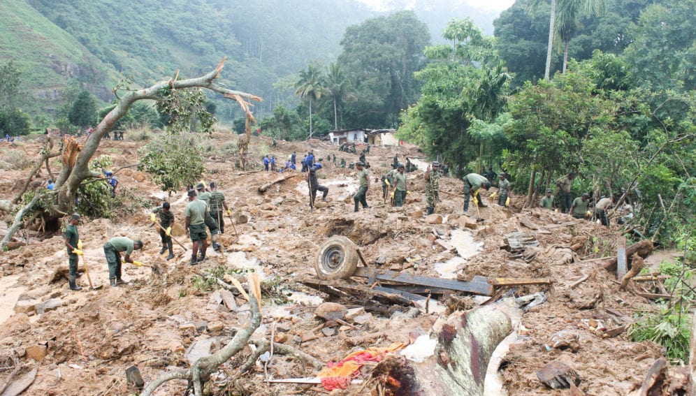
[COLOMBO] Following the May landslides, that left more than 100 people dead in the district of Kegalle, new areas have been identified as risky for human habitation.
“This is the new and increasing vulnerability profile of the area,” says R. M. Senarath Bandara, director of landslide research and risk mitigation at the National Building and Research Organisation (NBRO). “Over 600 new areas have been identified placing 2,800 families at risk.”
Hazards in the hilly district were known to have been exacerbated by long-term bad land use practices, including illegal forest clearing, construction and small crop cultivation, experts say.
The three hillside villages that were buried in the 17 May landslide had been declared off limits for human activity since 2002 when they were first marked as vulnerable, Bandara tells SciDev.Net.
According to Bandara, there had been years of ‘rapid and intense’ clearance of open, sparse forest of the area, exposing the hilltops to direct rain, with the cultivation of crops like cardamom and coffee further contributing to the region’s vulnerability.
“The entire sloped region in the landslide-prone area is not suitable for settlement and should be restricted for identified agricultural purposes,” says Bandara, calling for “urgent, scientific land-use patterns and reforestation programmes,” to contain the situation.Landslides have been occurring in the high-risk area over a long period of time, increasing slope instability. Lalith Chandrapala, head of the meteorological department, says that while Sri Lanka’s regular monsoonal experience has been intensified by extreme weather conditions there are strong possibilities that human activity intensified the impact at Aranayaka.
“The increase in rainfall, unprecedented during monsoons, denotes changing weather patterns. In Sri Lanka, monsoons are followed by flooding in several areas. This time, instead of several days, intense rainfall confined to just two days resulted in intense flooding and other impacts. That marks a serious change in weather patterns,” says Chandrapala.
He notes that the island’s climate vulnerability profile has changed in recent years with droughts and floods getting intense. “Sri Lanka’s vulnerability to landslides too seems to have increased due to a combination of heavy rains, geological changes in the hill country and deforestation.”
Anura Sathurusinghe, Sri Lanka’s conservator-general of forests, identifies illegal clearance as a main cause of deforestation — one of the island’s key environmental concerns.
“There had been continuous illegal clearance in vulnerable areas which threatens the safety of settlements it the foothills,” notes Sathurusinghe who identified bad land-use practices and deforestation as causes in a 2006 technical paper.
According to the World Bank, the island’s forest cover has declined from 33.4 per cent in 2011 to 30.0 per cent in 2015.
The island’s annual deforestation rate remains at 1.43 per cent. Sri Lanka’s fifth national report to the convention on biological diversity (2014) records the island’s open canopy sparse forest cover to be around 429,485 hectares (2010) with a total natural forest cover of 1,951,473 hectares.
To reverse a trend identified in 1992, new policies and targeted reforestation programmes have been introduced. “We have begun to stabilise, as reflected in the statistics,” says Sathurusinghe.


