By: Naimul Haq
Send to a friend
The details you provide on this page will not be used to send unsolicited email, and will not be sold to a 3rd party. See privacy policy.
[DHAKA] Backed by a new satellite observation system officials at Bangladesh’s Flood Forecasting and Warning Centre (FFWC) are confident of staying ahead of flood-related disasters in the country this season.
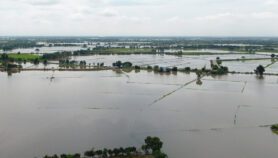
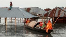
Every year, between March and September, monsoon rains and snow-fed rivers combine to inundate this deltaic country, resulting in damage to crops and property and loss of lives.
Experimental trials conducted last year by FFWC using data from the JASON-2 satellite — that was developed by SERVIR and the International Centre for Integrated Mountain Development — proved that an eight-day advance warning of floods was possible against the earlier three or four days.
SERVIR (acronym for ‘to serve’ in Spanish), a collaboration between NASA, USAID, and regional partner institutions, provides earth observation data and geospatial technologies to developing countries to better manage climate risks and land use.
SERVIR has regional centres in Nairobi, Kenya; Kathmandu, Nepal; and Bangkok, Thailand and a coordination office at NASA's Marshall Space Flight Centre in Huntsville, Alabama, US.
Mohammad Amirul Hossain, FFWC executive engineer, tells SciDev.Net that the new technology would supplement existing prediction systems that are based on complex ground water measurement. “The new technology helps to instantly translate data and forecast flood within about 30 minutes,” he says.
Arifuzzaman Bhuyan, a senior engineer with the Bangladesh Water Development Board, tells SciDev.Net that while it is important to have information such as river bed depth, slope, river width and river cross-sections, “these are not measured or shared among nations that make up the large river basins.”
The JASON-2 satellite is capable of accurately measuring water levels in rivers from points beyond the borders of Bangladesh on near-real-time basis.
“Now that we have the expertise to predict rising or falling river water trends our next goal is scaling up this experience and use more ground water measuring points which would give us even more accurate results,” Hossain said.
The new satellite forecasting warning technology could help evacuate millions of poor Bangladeshis in the Teesta, Brahmaputra and Jamuna river basins, which are prone to flooding.
Bangladesh, one of the world’s most densely populated countries, is located on the delta draining the Ganges, Brahmaputra, and Meghna rivers, making it prone to flooding. Its coastal regions are also vulnerable to tropical cyclone storm surges.
About 80 million people depend on flood warnings from the FFWC, which is already producing satellite-based water level predictions that are accessible on its website.
This article has been produced by SciDev.Net's South Asia desk.
More on Environment