Send to a friend
The details you provide on this page will not be used to send unsolicited email, and will not be sold to a 3rd party. See privacy policy.
As world leaders, experts and policymakers gather in Poland this week for COP24 — the 24th Conference of the Parties to the United Nations Framework Convention on Climate Change — an issue that could be key to the deliberations is a need for high quality and reliable data.
Solomon Hailu Gebrechorkos, a doctoral researcher from Ethiopia at Germany-based United Nations University Institute for Integrated Management of Material Fluxes and of Resources, conducts research that assesses the quality of climate data for improving water, food, and energy security of millions of people living in East Africa.
Gebrechorkos talks to SciDev.Net about high quality climate data issues in East Africa, the outcome of his latest research and its relevance to COP24 in Poland this week.
Why is East Africa one of the hardest regions to find good climate data?
There are two issues: availability and accessibility. In this region, even though ground stations are available, data quality issues such as missing values exist. In some parts of the region, even if the observed data is available, its accessibility is limited due to data sharing policies. For instance, in Tanzania, only five stations with a maximum of five years of observations are provided and at a high service charge. These five stations cannot represent the country and in these five years, there might be data gaps.
“In some parts of the region, even if the observed data is available, its accessibility is limited due to data sharing policies.”
Solomon Hailu Gebrechorkos, United Nations University Institute for Integrated Management of Material Fluxes and of Resources.
For climate studies, however, we need a minimum of 30 years of data and longer periods are preferred. Thus, the data sharing policies should be modified to make data easily available.
How can high quality climate data help vulnerable smallholders?
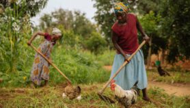
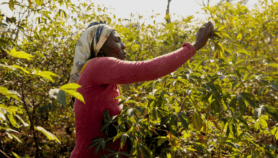
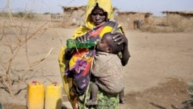
The impact of climate change on smallholder farmers is very high as they have no capacity to adapt to the changes. Because most smallholders are dependent on rain-fed agriculture, quality information can be very useful when fed to policymakers in the region, who are in a position to act on it.
For example, upon identifying areas with decreasing trends in rainfall and increase in temperature in a more accurate manner, resources can be mobilised to ensure that smallholder farmers become resilient to climate change.
Why is it important for policymakers in East Africa to care about high-quality data on climate change?
In Africa, there are plans to implement environmental management strategies for sustainable development.
We need good source of climate information to help us identify areas and problems such as increasing or decreasing in water availability and manage environmental resources more sustainably than previously possible.
High-quality data can support or facilitate decision-making and help in developing adaptation measures in sectors such as agriculture, energy and water.
What are the objectives, approaches and key outcomes of your research on climate data sources in East Africa?
Many climate data based on global climate models and remote sensing are available nowadays but their reliability is questionable.
Data issue is at the heart of integrated and climate adaptation management. We wanted to address it as comprehensive as possible for climate data in East Africa.
Our main objective was to identify suitable climate data sources because ground information from field-based meteorological stations is scarce in terms of spatial and temporal coverage.
“High-quality data can support or facilitate decision-making and help in developing adaptation measures in sectors such as agriculture, energy and water.”
Solomon Hailu Gebrechorkos, United Nations University Institute for Integrated Management of Material Fluxes and of Resources.
Under current conditions, concerning data availability and accessibility, the only feasible way to address this issue is to use climate data products from global data sources. Until now, there has been no comprehensive study which clearly identified the most reliable climate data product for this region.
With a focus on Ethiopia, Kenya, and Tanzania, we analysed the trends and variability of temperature for 1979–2010 and precipitation for 1981–2016. Our team was able to create high-resolution maps that correctly detected changes at local scale. The maps helped us to identify hot spots and provided useful data for the region than previously possible.
We think our approach, which was published in the International Journal of Climatology on 14 August this year, could help other sub-regions in Sub-Saharan Africa to get useful data on climate change. Future studies should carefully analyse whether those areas which we identified as dryer and having extreme climate events suffer low food security, low income and have more health problems.
Through our research, we identified the most reliable climate data products with high spatial and temporal resolution, and long-term changes and variability on seasonal, annual, and decadal in climate and climate extremes.
How relevant is your research to the United Nations Climate Change Conference in Poland in December?
At COP24, countries are expected to hold roundtables, among others, on resilience and climate action; and land use, water and energy.
The findings of this research have direct relevance to the conference. It helps to first get a good understanding of the current and future climate conditions of the region – even at a local scale, something which could not be provided by global climate models.
Such measures will help countries to achieve the UN Sustainable Development Goals on climate, water and food security.
Q&As are edited for length and clarity.
This piece was produced by SciDev.Net’s Sub-Saharan Africa English desk.
More on Climate change