By: Catarina Chagas
Send to a friend
The details you provide on this page will not be used to send unsolicited email, and will not be sold to a 3rd party. See privacy policy.
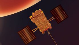
Brazil will launch a satellite in 2011 to monitor deforestation and urban expansion around the world, it has been announced.
Amazônia-1 will carry a UK-made high resolution camera. The United Kingdom–Brazil collaboration was announced last week (14 July) at the 60th Annual Meeting of the Brazilian Society for Progress in Science.
It is part of the continuing UK–Brazil Partnership in Science and Innovation, and stems from discussions between governments and research partners that began in 2007 during the UK–Brazil Year of Cooperation on Science and Technology.
Amazônia-1 will orbit the Earth 14 times a day at a distance of 400 miles, collecting images of several countries. It will have three cameras in total, two of them made in Brazil and one made in the UK.
The UK camera, RALCam 3, will be made by the Rutherford Appleton Laboratory based in Oxfordshire, and will provide images with each photo pixel showing ten metres of actual terrain — a technology without precedent in a Brazilian satellite.
The photos will aid environmental observation and inform natural resources management. It will be easier, for example, to identify illegal activity in forests, particularly in the Amazon and Congo rainforests, the two largest in the world.
Other applications include mapping of remote areas, and coastal and disaster monitoring.
"A few weeks after the launch, the satellite will start sending information," Thyrson Villela, director for satellites and applications at the Brazilian Space Agency, told SciDev.Net. The data will then be freely available to Brazilian research centres and those in countries all over the world. Having access to this information will help other tropical forest countries to fight their environment issues.
According to the UK Department for International Development (DFID), this project demonstrates the importance of science and scientific collaboration to address major global issues. DFID aims to work with other countries to build their capacity for satellite monitoring, drawing on Brazilian and UK expertise in this area.
Amazônia-1 is the first land monitoring satellite made entirely in Brazil. Its launch will be the first at the new Brazilian multi-mission platform, built by the Brazilian National Institute for Space Research. Both the satellite and the platform are government-funded enterprises.
More on Technology