By: T.V. Padma
Send to a friend
The details you provide on this page will not be used to send unsolicited email, and will not be sold to a 3rd party. See privacy policy.
Today’s maps are sophisticated tools, helping developing countries track everything from drought to disease, reports TV Padma.
With improved satellite imagery, data digitisation and information communication technologies, modern maps have come a long way from their static origins. Digitised maps and data can now be produced and transmitted swiftly across large distances through a technology known as geographical information systems (GIS).
GIS uses computer hardware and software to analyse and display geographical information. It can create digital maps overlaid with a variety of data. Developing countries can then tailor the data to their needs, mapping anything from floods or crop stress to disease outbreaks.
This is proving a boon to development planners who often find that statistics and maps are out of date, inaccurate or poorly maintained.
Managing disease
Health officials in the southern Indian state of Andhra Pradesh have been frustrated for years by difficulties in tracking outbreaks of Japanese encephalitis. It took 16 days, at best, for news of a case in a small village to reach government officials in the state capital, Hyderabad. By the time the health ministry had collated the relevant data and confirmed the cases, an epidemic was upon them.
Today, health services can receive information within a few hours. The National Informatics Centre (NIC) in Hyderabad receives information on disease cases directly from health workers through the Internet, which can then be mapped quickly using GIS.
"GIS helps us to quickly map and identify areas of high incidence, and even update the maps with each new data entry," says K Rajasekhar, senior technical director at NIC.
Furthermore, the technology can generate a map to show where primary health centres are absent. This shows where new centres are really needed and guards against locations determined at political whim.
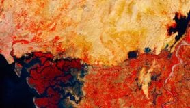
 |
| Satellite map of Al Fashir, Darfur, showing settlements, roads and geographical features |
| Credit: Respond |
In Thailand, GIS is being used to follow the bird flu epidemic that remains a major concern in Asia. In 2006, the Asian Institute of Technology (AIT) in Bangkok launched a project to map and track fatal strains of the virus, identifying risk zones and the trajectory of any potential outbreak.
At a gathering of international GIS experts in Hyderabad in January, the AIT presented preliminary data showing that countries with temperatures of 25–30 degrees Celsius that get around 50 millimetres of rainfall each year reported most outbreaks.
AIT also displayed maps showing how the H5N1 virus spreads rapidly two months after the first outbreak. This kind of information is crucial in developing best practice for outbreak prevention on farms, says AIT scientist Nitin Tripathi.
And in January, the French Institute of Pondicherry (IFP), India, launched a project to map areas vulnerable to outbreaks of chikungunya and dengue fever in southern India. "We want to study correlations between the type of landscape and vulnerability to disease outbreaks," says Frédéric Borne, head of IFP’s geomatics and applied informatics laboratory.
Monitoring disasters
GIS is increasingly employed for environmental and disaster management, with satellite images used to monitor floods, hurricanes, droughts, landslides, fires and oil spills. Emergency workers can use GIS to prepare maps of disaster zones, visualise disaster scenarios, and develop advanced spatial models and management plans.
In Iran’s Isfahan province and the Prabhani district of central India, remote sensing and GIS are helping officials prepare updated erosion maps. These detail slopes, soil type, drainage patterns and areas where ground water could potentially be replenished, either naturally through rainwater or artificially through aquifers.
Basanta Shrestha, head of the Mountain Environment and Natural Resources’ Information System in Nepal, says many issues of mountain development such as environmental degradation, deforestation, floods and sharing of water resources, have a strong geographical component.
"There has been a growing awareness that GIS and related technologies are indispensable tools in analysing environmental issues in mountains," he added.
 |
| Satellite map of Banda Aceh, showing flooded land (blue) and devastated (red) and affected (pink) urban areas |
| Credit: UNOSAT |
Indonesia is also using GIS to delineate areas with strong erosion in the Bandung Basin of West Java. Meanwhile, neighbouring Malaysia is using GIS to track the haze pollution caused by Indonesian forest fires, and to manage urban planning records.
Elsewhere, GIS is being used to tackle social problems. In Afghanistan, which provides 92 per cent of the world’s illicit supply of opium, the UN Office of Drugs and Crime is using GIS technology to monitor opium crops. And in Delhi, GIS is helping the government to monitor unauthorised constructions in real time.
Stumbling blocks
However, a number of issues block the widespread use of GIS technology.
A major problem, according to Indian science minister Kapil Sibal, is availability of resources. The computer hardware and software, data and licensing policies are not available in all countries.
Also, satellite images alone cannot be relied upon and need to be verified with ground surveys. In 2006, for example, Malaysia found that only 10 per cent of 6000 thermal hotspots indicated in satellite images were real fires. Multiple detection systems are needed to eliminate false signals.
Even with better software and skilled database specialists, GIS faces further problems. With private companies, non-governmental organisations and other international players as potential users, governments still hesitate to make GIS information available in the public domain, citing security reasons.
"For historical reasons [political conflict or cultural mistrust], it is widely assumed that Asian economies will not cooperate when sharing GIS databases," warned Y.B. Dato’ Seri Azmi Khalid, Malaysia’s minister of natural resources and environment.
Some countries have already initiated policy changes. In 2005, India announced a ‘dual-series’ policy, putting some of its digital maps in the public domain whilst retaining others for security agencies. India also plans to set up a National Spatial Database Infrastructure, which will give people access to maps at local community, state, regional and national levels.
But even if GIS maps are shared more widely, there remains the problem of standardising the data. The same set of data often cannot be used by different agencies with different needs. Maps designed for monitoring floods, for example, cannot be overlaid with data to track malaria incidence.
Equally important is the cost. According to Mangudi Panchapakesn Narayanan, president of the India’s Geospatial Communications Network, the price of hardware has come down but the software is still expensive. He says the poorest countries will be able to afford the technology if the price is halved. "What is needed is government and industry support," he says.
Narayanan believes that an increase in the number of users will also help drive down the cost. Some experts support a drive for an open-source version of GIS software, allowing free duplication, changes and redistribution.
But there are also issues involving intellectual property rights. Patents have been granted for some GIS maps. According to George Cho, professor of geoinformatics at the University of Canberra in Australia, "There are still grey areas [regarding] governments’ national security concerns, right to privacy of individuals and ethical use of GIS data."
But as geospatial information becomes more important in emergency and disaster management, it will be critical to resolve these issues and ensure that relevant data gets to the countries that need them most.
More on Earth science