By: Shishir Dube
Send to a friend
The details you provide on this page will not be used to send unsolicited email, and will not be sold to a 3rd party. See privacy policy.
Investing in detailed maps of potential cyclone damage will save lives in Indian Ocean countries, says Shishir Dube.
Recent Asian killer cyclones — Sidr in Bangladesh in 2007 and Nargis in Myanmar in 2008 — focused attention on the deadly storm surges associated with severe tropical cyclones.
These surges happen when intense winds blow over large surfaces of water that are bounded by shallow basins. Seawater ‘piles up’ against the coast, causing flooding that threatens lives and crops as well as infrastructure and property.
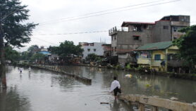
Storm surges are serious hazards along the east coast of Bangladesh, India, Myanmar and Sri Lanka. Cyclones may be more frequent in the Atlantic or Pacific, but the Bay of Bengal’s shallow coastal water, high tides and densely populated low-lying areas make surges particularly deadly here.
About 300,000 people died in November 1970, when a severe cyclone hit Bangladesh (then East Pakistan). A cyclone at Paradip on India’s east coast killed more than 15,000 in October 1999. And in Myanmar, the recent cyclone Nargis caused over 100,000 deaths.
Progress on forecasts
Predicting storm surges with enough warning to evacuate people is a challenge for scientists. Yet many countries surrounding the North Indian Ocean have achieved some success. Improved storm surge models can now provide warnings with a lead time of 12 to 24 hours.
Much of this success has been due to member states cooperating under the World Meteorological Organization’s Tropical Cyclone Programme. For example, the programme has helped the Indian Institute of Technology in Delhi, India, to develop and implement well tested storm surge models for Bangladesh, Myanmar, Oman, Pakistan and Sri Lanka.
Vulnerability mapping still needed
But there remains a serious knowledge gap on another front — the backbone of any cyclone disaster management plan is understanding an area’s physical vulnerability.
Researchers need to work out how much of a coastline is likely to be affected by strong cyclonic winds or inundated by storm surges.Calculating this physical vulnerability is becoming especially important, given projected global warming and sea level rise. To be most useful, vulnerability should be calculated using the smallest possible geographical unit of the coast, such as villages.
Countries vulnerable to cyclones and storm surges are aware of the issues and very detailed vulnerability maps are available for many developed nations, like Australia and the United States. But countries like Bangladesh, Myanmar, Pakistan and Sri Lanka lack the data and technology to produce such maps.
Still, there has been some progress. The Indian Institute of Technology in Delhi carried out a pilot study in 2005 to prepare vulnerability maps for the coast of India’s southern state of Andhra Pradesh.
Scientists from the Institute used a database of storm surges in the region combined with simulated cyclone tracks and tidal characteristics. They calculated potential flooding and wind damage, and mapped vulnerability to future cyclones, including less frequent but more intense events.
The maps have informed long-term disaster management plans in the area. District authorities can use them to identify the areas at most risk of flooding and wind damage, determine priorities for mitigation and regulation strategies, and guide relief and insurance policies.
Proposals are under way to prepare similar maps for other coastal states. Emergency managers and decision makers are increasingly requesting maps of flood risk as well as the normal forecasts of storm surge timing and height. Flood risk maps are also needed inland because of the high rainfall associated with cyclones. Such maps help prepare for, respond to, and assess cyclone damage.
Essential investments
But for most countries round the Indian Ocean, detailed coastal and onshore digital topography data do not exist (and are expensive to collect). So vulnerability mapping would require considerable investment in technology and computing resources as well as in collecting detailed data at small spatial scales.
Detailed histories and data dossiers for individual storm surges are also lacking. These are needed to help calibrate storm surge models and improve prediction techniques, as well as to assess coastline vulnerability and manage cyclone mitigation plans.
Countries must make an effort to collect and store all pertinent data when a cyclone hits. For example, geographical information systems (GIS) are now a common research tool, and can create databases of rainfall, stream flow and cyclone tracks.
Investing in both technology and data collection will help vulnerable countries develop the detailed physical vulnerability maps needed for efficient evacuation strategies. These are investments that can reduce the death toll of Indian Ocean cyclones.
Shishir Dube is a professor in the Centre for Atmospheric Sciences at the Indian Institute of Technology, Delhi.
This article is part of a Spotlight on Tropical cyclones in the Indian Ocean.
More on Disasters