By: Saleem Shaikh
Send to a friend
The details you provide on this page will not be used to send unsolicited email, and will not be sold to a 3rd party. See privacy policy.
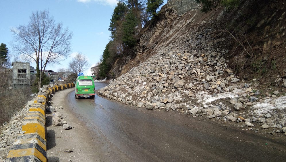
[ISLAMABAD] A landslide susceptibility map, developed from a remote sensing-based landslide inventory, can help define and implement landslide mitigation strategies in Pakistan’s mountainous regions. This, according to the authors of a study based on satellite imagery and field observations in the vast Central Karakoram National Park (CKNP) area in northern Pakistan.
The CKNP, the highest national park in the world, is home to four peaks higher than 8,000 metres and shares borders with Afghanistan, China and India. The famed Karakoram Highway, now a part of the China-Pakistan Economic Corridor, is prone to landslides.
“We would look into the landslide inventory study results and hammer out mitigation measures accordingly to protect lives and livelihoods of the mountain communities as well as public infrastructure in the study area”
Yasmin Rizvi, Geological Survey of Pakistan
According to the study, areas close to the 100-metre buffer of roads in the CKNP were found to be extremely vulnerable to landslide risks while those at a distance of 101 to 200 metres are the second most landslide-vulnerable locations, say the findings of the study published this month (April) in the Egyptian Journal of Remote Sensing and Space Science.
“We mapped 314 potential landslide sites covering a total area of 112.53 square kilometres in the study area, which is home to over 600 glaciers, including Baltoro, Biafo, and Hispar and dozens of glacial-fed mountain streams and glacial lakes,” Muhammad Shafique, study author and assistant professor at the National Centre of Excellence in Geology, University of Peshawar, tells SciDev.Net.
The combined impact of active tectonics, high seismicity, rough topography, fractured geology, shifting weather, more frequent intense rains and anthropogenic activities, including blasting on the unstable slopes for housing and road construction, are among leading causes of landslides, says the study, which has helped develop the first landslide susceptibility inventory of the CKNP.
The researchers found that landslide occurrence is sporadic in areas with terrain slope greater than 70 degrees because of the presence of cliff without colluvium cover. Terrain with a 50 to 60-degree gradient was found to be most prone to landslides.
Barren and irrigated agricultural lands also showed a high frequency of landslide events. On the other hand, areas characterised as forest, shrub lands and alpine pastures have been found to be least vulnerable to landslides, according to the study.
Landslide events in Pakistan's rugged mountain areas lead to deaths, injuries and displacement and cause damage to water, transport, health and education infrastructure besides disrupting agriculture activities.
Yasmin Rizvi, director-general of the Geological Survey of Pakistan, says the findings are promising and scalable to landslide-vulnerable regions in other mountain regions of the country such as Mansehra, Chilas, Chitral, Skardu, Hunza, and Skardu districts in Pakistan’s north-west region.
“We would look into the landslide inventory study results and hammer out mitigation measures accordingly to protect lives and livelihoods of the mountain communities as well as public infrastructure in the study area,” she tells SciDev.Net.
Rizvi says that mountain slope stabilisation measures could help prevent landslides. These measures include retaining walls, applying bioengineering techniques, tree plantation, installing boulder and debris catching nets, and the construction of drainage networks to capture surface run-off and block its slippage into mountain cracks.
Equally important, she says, is sensitisation of local communities about landslide-prone sites. They should be empowered with knowledge of self help-based protection measures and landslide-safe land-use planning, as well as trained in life-saving. Another viable strategy for landslide risk mitigation in the region is the establishment of community-based early warning systems.
Gilgit-Baltistan Disaster Management Authority’s director-general Fareed Ahmed says his organisation is already engaged with authorities to mitigate landslide risks. “Our organisation is working with government and non-governmental partners to introduce building codes for promoting landslide-safe infrastructure and housing in the landslide-prone areas so as to avoid displacement of people or restricting their mobility.”This piece was produced by SciDev.Net’s Asia & Pacific desk.


