By: Naimul Haq
Send to a friend
The details you provide on this page will not be used to send unsolicited email, and will not be sold to a 3rd party. See privacy policy.
[DHAKA] A study released this month (July) warning of tectonic plates beneath Bangladesh, eastern India and Myanmar colliding to cause a mega-earthquake has come up against criticism from top geologists.
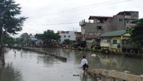
The study, published in Nature Geoscience, suggests that a locked megathrust plate boundary represents an underappreciated hazard to Bangladesh, a country with more than 160 million people and one of the most crowded places on earth.
“Using 26 GPS tracking stations across Bangladesh we determined which part of the fault was locked. The fault is shallow (3—5 kilometres) at the western end and deeper (25 kilometres) at the eastern end,” Michael Steckler, chief investigator of the study and research professor at the Lamont-Doherty Earth Observatory, Columbia University, tells SciDev.Net.
Steckler predicts that a potential earthquake could start at the deep end of the fault at 25 kilometres and propagate upwards. “The earthquake would not only affect Bangladesh but also northeast India, including (the states of) Assam, Meghalaya and Mizoram.”
“The earthquake is not imminent; it may not happen for hundreds of years,” Steckler says. He, however, says “there is an opportunity to slowly make Bangladesh more resilient and better prepared.”
Syed Humayun Akhter, a structural geologist at Dhaka University and co-author of the study, tells SciDev.Net that the danger comes from “Bangladesh floating on soft soil that could amplify the earthquake wave, causing deadly disasters if a mega-earthquake measuring nine on the Richter scale takes place.”During 2003—2014, the researchers studied Bangladesh’s movement relative to the Indian peninsula and combined it with GPS readings that show Myanmar’s Shan Plateau moving southwest at a rate of nearly two inches (46 millimetres) a year.
“Our study shows that a segment of 250 x 250 square kilometres fold-thrust belt of the Indo-Burman Range between Chittagong and Sylhet has been building up huge elastic energy for over 400 years due to the oblique convergence of the India and Burma plates,” Akhter says.
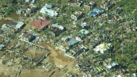
Akhter believes that the accumulated energy of the locked megathrust could generate a potential earthquake of 8.2— 9 on the Richter. “Such a mega-earthquake could be devastating for an overpopulated country like Bangladesh.”
But, these predictions have been challenged by other experts.
Netai Dey Sarker, at Bangladesh’s department of disaster management, tells SciDev.Net that the models could have considered more specific research on earthquake probability. “If the collision is inter-plate then there is risk of a mega-earthquake, but if it is an intra-plate collision then it is questionable whether there is enough stored energy to cause such a wave to shake the land above.”
Badrul Imam, professor of geology at Dhaka University, describes the study as “overly conjectural”, and says that while GPS studies represents upscale technology, “the interpretation of data left certain vital geological questions unanswered.”
“I understand that the GPS readings they followed make a clear case of plate movement. But to make an 8—9 intensity earthquake prediction based on such indirect evidence is not justified,” Imam tells SciDev.Net. “There is no geological evidence for a megathrust running through the Bengal plain and Dhaka city as shown in the paper.”
More on Disasters