By: Ranjit Devraj
Send to a friend
The details you provide on this page will not be used to send unsolicited email, and will not be sold to a 3rd party. See privacy policy.
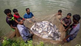
[NEW DELHI] A satellite navigation system, designed to guide aircraft landing and taking off at airports, is now ready to fill the communication gap for about a million fishermen who risk their lives fishing around the Indian peninsula.
Key to the breakthrough is GEMINI, a simple handheld device which collects data from the GPS-aided geo-augmented navigation (GAGAN) system used at Indian airports and transmits it to mobile phones via an app. GEMINI is acronym for GAGAN Enabled Mariner’s Instrument for Navigation and Information.
“GEMINI is manufactured in Bangalore by a local company and although it is cheap it covers the seas around India and can be sold for use by countries in the entire Indian Ocean rim”
Balakrishnan Nair, INCOIS
So far, communication with fishermen has been limited to mobile networks and very high frequency (VHF) radio which do not range over 20 kilometres, while fish shoals in the Arabian Sea, Bay of Bengal and Indian Ocean are as far away as 150 kilometres from the coast. At such distances it becomes impossible to provide timely warnings of sea storms and cyclones to fishermen.
“If only we had this device when Cyclone Ockhi hit the western coast in November 2017, we could have saved the lives of hundreds of fishermen lost at sea,” said India’s minister for science and technology Harsh Vardhan when he officially launched GEMINI on 9 October. Officially, Ockhi claimed 245 lives — 218 in India and 27 in Sri Lanka.
The device is the result of collaboration between Indian National Centre for Ocean Information Services (INCOIS) and the Airport Authority of India which has been operating the GAGAN system at its airports since February 2014 using several geosynchronous communication satellites designed and launched by the Indian Space Research Organisation.
Apart from providing storm and disaster warnings or Ocean States Forecast, the system also transmits locations of fish shoals by mapping Potential Fishing Zones to help enhance the livelihoods of fishermen, according to Satheesh Shenoi, director of INCOIS.
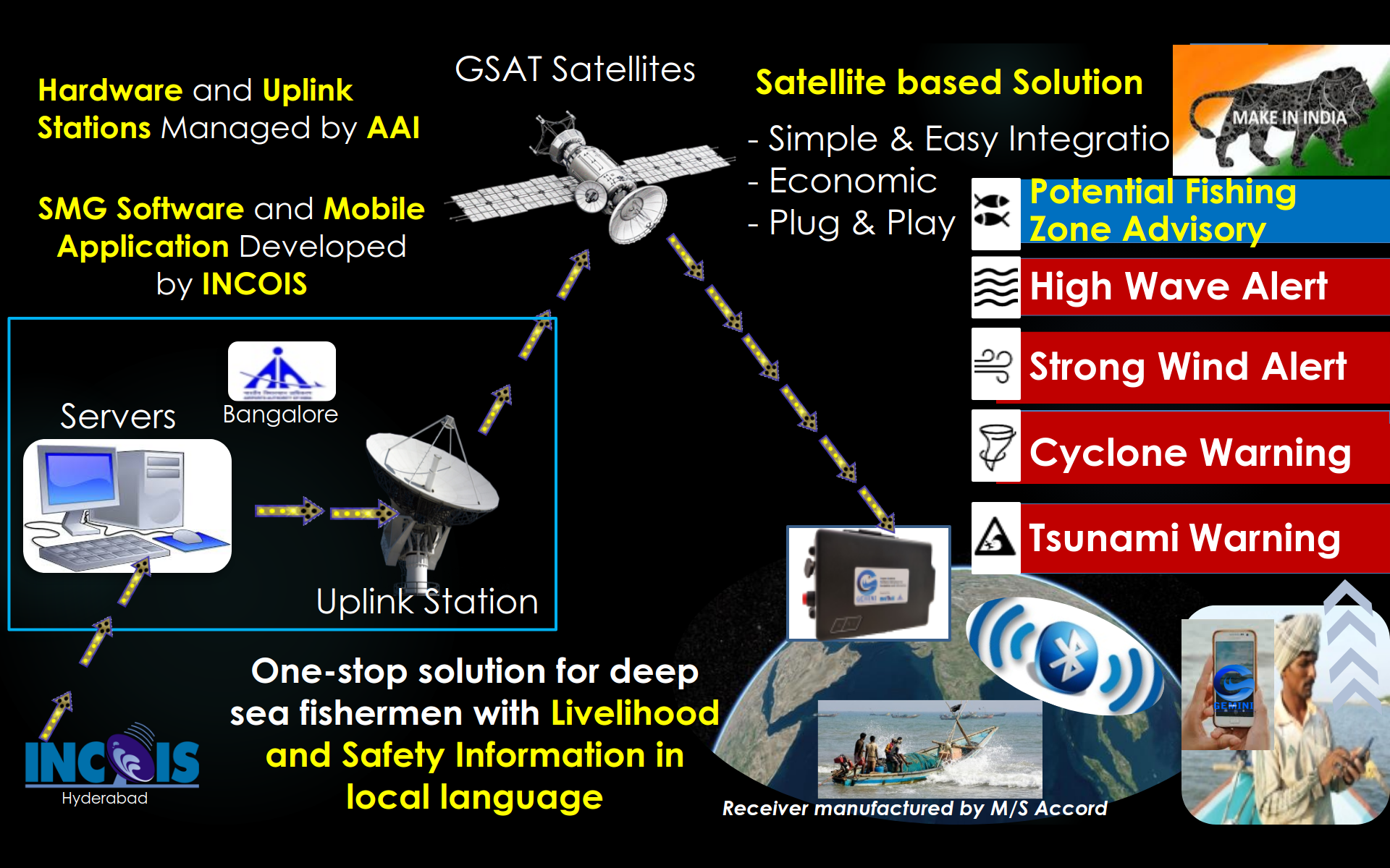
How GEMINI works. Credit: INCOIS.
“GEMINI is manufactured in Bangalore by a local company and although it is cheap it covers the seas around India and can be sold for use by countries in the entire Indian Ocean rim,” says Balakrishnan Nair, a scientist with INCOIS.
According to Nair, the system detects potential fishing zones by using the same parameters as other satellites (such as sea-surface temperature and chlorophyll content) to provide forecasts three days in advance. He says an estimated 900,000 Indian fishermen and others from the Maldives, Sri Lanka and other states around the Indian Ocean will benefit from both the Potential Fishing Zones and the Ocean States Forecast services.
A GEMINI set is available from Accord Software and Systems, the manufacturers, at $US140, about the price of a low-end smartphone. Distribution has been left to the Department of Fisheries and concerned local governments which may have policies on concessional rates. Once acquired all that a user needs to do is download an app into a Bluetooth enabled mobile phone.
For India, the department of fisheries has plans to fund the distribution of GEMINI sets to fishermen, Nair tells SciDev.Net.
India’s autonomous regional satellite navigation system, called NAVIC, provides accurate real-time positioning and timing services. Navigation satellite systems currently in operation include GPS, operated by the US and Russia’s space-based satellite navigation system GLONASS. China’s BeiDou Navigation Satellite System and the European Union's Galileo are expected to be fully operational by 2020.
“This is the best system developed so far in terms of effectiveness and affordability, especially if supported by the fisheries department,” says John Swamy, a maritime safety consultant and a former officer in India’s merchant navy. “It does have the drawback that communication is only one way.”
Swamy has been lobbying for the use of satellite phones, currently banned for general use in India because of security reasons. “With satellite phones anyone can voice call a fisherman anywhere and ask him to get back home when there is impending peril.”
“VHF radio systems, which have been in use for a long time, depend on line of sight and cannot transmit beyond the horizon which is around five kilometres — besides, there are protocols for their use and can get crowded in by too many users at [a] given time,” says Swamy. “As for mobile phones, the reliable limit is less than 20 kilometres,” he says.
“The best part of GEMINI is that the information is available in several Indian languages and can be used by any fisherman in a small launch as long as he has a mobile phone with sufficient battery power,” Swamy says.
This piece was produced by SciDev.Net’s Asia & Pacific desk.
More on Fisheries