By: Rasha Dewedar
Send to a friend
The details you provide on this page will not be used to send unsolicited email, and will not be sold to a 3rd party. See privacy policy.
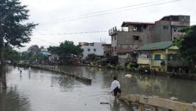
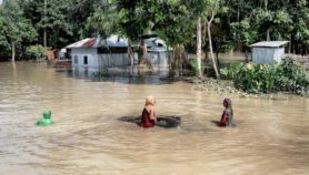
[CAIRO] A disaster response programme developed by a Qatari institute proved useful in the aftermath of the 25 April and 12 May earthquakes in Nepal that killed an estimated 9,000 people and affected three million others.
Immediately after the April temblor, the UN sought activation of the Artificial Intelligence for Disaster Response (AIDR) programme, developed by the Qatar Computing Research Institute (QCRI).
The programme relies on key words to identify and classify social media content following a disaster and shares results with humanitarian agencies in the field, QCRI officials say.
“Within 24 hours of the first tremors in Nepal, the UN asked us to initiate AIDR and MicroMappers so that we could immediately begin gathering tweets related to the destruction,” Patrick Meier, director of social innovation at QCRI, tells SciDev.Net.
The early activation allowed the mapping of affected areas even before relief agencies landed in Nepal. “The responders had a good picture of the areas that were worst damaged before they had even touched down in Kathmandu,” Meier says.
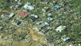
UN humanitarian agencies relied on the AIDR programme in relief efforts when Pakistan was hit by an earthquake in 2013 and when the Philippines was hit by Typhoon Haiyan in November that year. More recently, it was handy during the tropical cyclone that hit Vanuatu Island in March 2015 and when Typhoon Hagupit devastated the Philippines in December 2014.
MicroMappers, another platform developed by QCRI jointly with the Standby Taskforce relief agency and the UN Office for the Coordination of Humanitarian Affairs (OCHA), depends on thousands of qualified volunteers all over the world who can access and classify information which can be processed using AIDR.
MicroMappers developed to handle streams of data from Twitter and also SMS, images, videos, satellite, and aerial imagery,” Kimberly Mathern, a volunteer, tells SciDev.Net.
“Expressions of need are captured and shared with assessment teams as a secondary data source and this helped develop a better understanding of the situation and the needs,” says Andrej Verity, programme officer at OCHA.
According to Meier, AIDR can auto-classify some 30,000 tweets per minute, and gives volunteers an estimate of accuracy in classifying tweets so that the volunteer can reuse the same classifier while dealing with other disasters.
“Given that these tools aim to funnel Twitter down to something manageable for responders, I would say that they are quite efficient. Simply compare how many humans it would take to read all the Twitter messages after such an earthquake. AIDR accepts all messages and then filters and assigns a confidence level,” Verity says.
There are challenges such as the credibility of information on social media. But this, according to Meier, is handled through ‘Verily’, an evidence based tool that uses crowdsourcing to verify information on social media.
“Integrating with disaster response frameworks is another challenge facing the programme,” Meier says.
Social media is mainly used to corroborate other sources, says Verity. “We only use social media data as another source. As with any data source it comes with its own bias.”
A version of this story originally appeared in SciDev.Net’s Middle East & North Africa edition.
More on Disasters