Send to a friend
The details you provide on this page will not be used to send unsolicited email, and will not be sold to a 3rd party. See privacy policy.
More must be done to prevent damage of ocean data buoys that costs money, vital data — and lives, say Sidney Thurston and M. Ravichandran.
The global community relies on a rapidly expanding ocean observing network to understand the climate and ecosystems, to help warn against ocean-borne hazards such as tsunamis and storm surges caused by cyclones, and to support sea rescue missions.
Sensors attached to moored or drifting buoys gather meteorological and oceanographic data and transmit them in real time, via satellite, to scientific and operational communities across the world.
For example, the Global Tropical Moored Buoy Array (GTMBA) (see figure 1) provides real-time data for climate research and forecasting. Its major components — including the TAO/TRITON array in the Pacific — monitor a range of phenomena including the El Niño/Southern Oscillation (ENSO) in the Pacific, hurricane activity in the Atlantic, and monsoons in the Indian Ocean.
")
Figure 1. Map of the Global Tropical Moored Buoy Array network, showing sites in the Atlantic, Indian and Pacific oceans
Source: NOAA
But all types of moored ocean data buoys are increasingly at risk of damage — whether deliberate vandalism or through negligence.
At its worst, vandalism and damage threatens the very sustainability of some major observation networks, or substantial parts of them. It pushes up operating costs and, crucially, it erodes the value and community benefit that monitoring equipment provides through scientific knowledge.
Countries and fishers in South-East Asia must act against ocean buoy vandalism.
Buoy damage costs
Vandalism and negligent damage takes many forms. It includes routine ship collisions, damage from fishing lines, nets or cables, and direct exploitation of moorings such as fish aggregation devices.
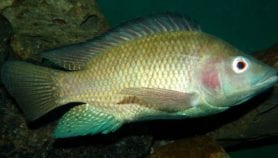
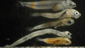
For example, when small fishes aggregate near the buoy to consume algae growing on the buoy they attract big fish, and in the process large fish schools can congregate around the buoy. Fishers who try to fish near the buoy get entangled with the mooring, and when they try to retrieve their nets, they damage mooring lines and sensors fitted on the buoys.
Sometimes nets drift due to currents, especially during the night, and become entangled with a buoy. Fishers angry about tangled nets may damage the buoys with gunshots, or may steal entire systems or their components. This is a sad but true reality that can, and should be avoided.
Damage is most common in the Indian Ocean. Over half of the 36 tsunami moorings in the newly established Indian Ocean Tsunami Warning System and Adjacent Seas network were damaged over a period of four years.
Over a 9-month period in 2008, 18 TAO stations in the Tropical Pacific went offline due of vandalism. Restoring them cost more than $1 million.
And in the Indian Ocean, tsunameter (equipment used to detect tsunamis) networks have suffered over 30 vandalism incidents in four years, affecting over half the stations at a cost of over US$3.5 million.
Wherever the damage occurs, it multiplies the budget needed to maintain these systems. Not only that, crucial data are lost to both early warning systems and longer term climate research.
In turn, this downgrades weather and marine forecast capabilities, makes tsunami warning systems less reliable and undermines confidence in them. The result could be significant loss of life and property as well as costly evacuations in response to false tsunami warnings.
Regulations, but not only
In December 2009, the Western and Central Pacific Fisheries Commission adopted a binding measure to protect moored data buoys by restricting fishing within one nautical mile.
In September 2010, the Inter-American Tropical Tuna Commission (IATTC), at its eighty-first meeting, adopted a similarly worded non-binding Recommendation Prohibiting Fishing on Data Buoys. These measures offer a new regional management practice to minimise intentional or unintentional damage to ocean data buoys.
The measures prohibit participating member states from fishing or interacting with a buoy within one nautical mile of the instrument or its mooring line; attaching a boat or any fishing gear to a data buoy or cutting a data buoy anchor line; or taking on board a data buoy unless specifically authorized to do so.
But these regulations are not enough to prevent damage in many developing countries. Fishers need much better awareness of why these ocean buoys are important, and how they benefit their own lives by helping with early warning of severe weather, cyclones and tsunamis, and even providing data that help identify areas where fish are likely to be abundant.
As for damage from deep-sea fishing vessels, concerned ports need to do more to promote awareness about the importance of these monitoring systems.
And both fishermen and commercial shipping need practical information about the location of buoys.
Ultimately, it is up to everyone using the ocean to realise that maintaining these buoys holds tremendous benefits to their lives and livelihoods.
Sidney Thurston is international coordinator at NOAA’s Global Ocean-Climate Observations programme in Maryland, United States. M. Ravichandran is a scientist and head of the Modeling and Observation Group of the Indian National Centre for Ocean Information Services, Ministry of Earth Sciences, India.
This article is part of a Spotlight on Ocean science for sustainable development.
More on Fisheries