By: Geoff Wadge
Send to a friend
The details you provide on this page will not be used to send unsolicited email, and will not be sold to a 3rd party. See privacy policy.
Volcano expert Geoff Wadge explains how the International Charter on Space and Major Disasters helped manage a volcanic eruption in Montserrat.
The International Charter on Space and Major Disasters aims to provide timely and targeted satellite data during an emergency.
It gives disaster managers an official route for getting satellite sensors, run by cooperating space agencies, to obtain images of problem areas.
Experience from the small Caribbean island of Montserrat shows such data can be invaluable. They can prove crucial to planning an effective emergency response if local expertise is already focused on the problem and available to take swift action.
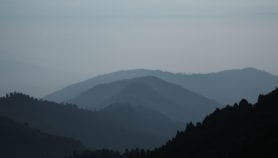
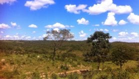
The Soufriere Hills volcano in Montserrat has been active for more than 14 years. While many months can go by with no hazards, there are often periods of very high risk.
The government manages this fluctuating risk by keeping the southern two thirds of the island uninhabited, while people still live in a zone that can be easily evacuated in the face of immediate danger.
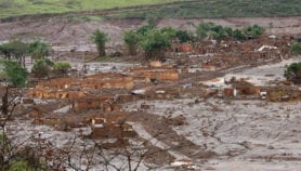
So when the volcano exploded on 28 July last year (2008), showering fist-sized pumice fragments over the inhabited areas, the government ordered an evacuation of people closest to the volcano.
Scientists at the Montserrat Volcano Observatory (MVO) had already been measuring a swarm of earthquakes beneath Soufriere Hills, as new magma rose into the volcano.
So had the explosion made the volcano more dangerous? Or would it be less hazardous over the coming weeks? And if it was less dangerous, could the evacuation be revoked?
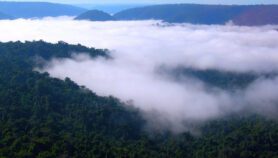
Shrouded in cloud
In the years running up to the explosion a large dome of lava a few hundred metres across had grown. If this collapsed, it would send deadly ‘pyroclastic’ flows of super-hot gas and rocks towards the occupied areas. Had the explosion made this dome more unstable?
To answer this, the scientists needed to observe the dome. But Soufriere Hills was covered in cloud.
As luck would have it, one of the MVO scientists had just been on a course in remote sensing for disaster management and knew of the international charter. Knowing my expertise in volcano remote sensing, he contacted me and, on 29 July, we activated the charter via the UK government (Montserrat is a UK Dependent Territory).
What we needed was detailed images of the lava dome beneath the cloud, to examine small features and tell what changes had occurred during and after the explosion. Only radar can see through cloud, and several satellite radars, available through the charter, were tasked to acquire images.
The devil’s in the detail
But we were worried that these radars would not supply data at sufficiently high resolution. The highest resolution civilian radar, TerraSAR-X, is owned by the German space agency (DLR), which is not yet signed up to the charter.
Luckily, DLR nevertheless agreed to collect TerraSAR-X data over Soufriere Hills and we received new images on 2 August. More importantly, they also gave us earlier images acquired before the explosion that let us see the changes.
After processing the two sets of images to emphasise changes to the dome’s surface, we had our answer the same day — the explosion had punched a relatively small new vent through the lava dome but had not made it less stable as a result.
The MVO submitted this conclusion to Montserrat’s civil protection committee, which, on 6 August, used it as grounds to revoke the evacuation order and allow people back to their houses.
It wasn’t until more than a week later (14 August) that the cloud cleared sufficiently to confirm the radar interpretation.
Charter, expertise… and luck
There is no doubt that satellite data accessed through the charter helped guide an effective response to this natural hazard. Although you could argue that the data that solved the problem did not actually come from the charter, it was the charter’s acceptance of our case that convinced DLR to help.
But the charter itself was not the only factor underpinning our success.
Montserrat had specific expertise in remote sensing and was already monitoring the volcano’s behaviour before the crisis. So scientists recognised the exact need and which satellites could help, and they knew the way to get data quickly (the charter). Starting ‘from cold’ may have taken longer or missed the route to the solution.
And there was another element of luck: TerraSAR-X had already acquired appropriate ‘before’ images of the volcano.
Could better be done next time? Our luck with the ‘before’ images highlights the need for a global archive of satellite imagery to help with future disasters. Having DLR as part of the charter would also formalise access to their valuable resource.
And while the UK government responded quickly, the contact details we needed to activate the charter are not easily available on the Internet. Only authorised users from Charter member countries can request images. Neither the British National Space Centre nor the Charter itself had the contact information available online.
On our side, we could have been better prepared had we asked ourselves what archival data we might need to be able to respond to the type of scenario we faced on 28 July 2008.
Geoff Wadge is a professor in the Environmental Systems Science Centre at University of Reading, United Kingdom and chairman of the Foreign and Commonwealth Office’s Scientific Advisory Committee on Montserrat volcanic activity.
More on Earth science