Send to a friend
The details you provide on this page will not be used to send unsolicited email, and will not be sold to a 3rd party. See privacy policy.
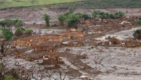
For years, scientists have discussed bringing together information from all of the instruments monitoring the Earth’s environment — such as satellites and weather stations — into a single unified system. The devastation wreaked by last year’s Asian tsunami provided the trigger needed to set these plans in motion (see Global system to improve and unify Earth observation).
Evaluations after the tsunami showed that poor communication between the Earth’s monitoring systems prevented them from providing a timely warning, reports Naomi Lubick.
The Global Earth Observation System of Systems (GEOSS) is being designed to fill this gap by linking more than 50 satellites and thousands of observation stations on land and at sea.
Scientists do share such information, but not consistently, says Lubick. Previous efforts to create a unifying system have suffered from lack of funding, and there is a chance this one could too. The United States has met most of the initial costs of US$750,000 but its long-term support cannot be guaranteed.
Another obstacle is that some countries are reluctant to share data. India, for example, classifies seismological data as being of national security importance and will not release it immediately — something that would be crucial to warn of a tsunami.
If these hurdles can be overcome, however, GEOSS could have a substantial impact on Earth sciences, Lubick concludes.
More on Earth science