By: Lou Del Bello
Send to a friend
The details you provide on this page will not be used to send unsolicited email, and will not be sold to a 3rd party. See privacy policy.
The cardboard box is covered with a layer of dust so thick it must have been tucked away in this Kenyan basement for decades. The researcher wipes off the dust and rummages through the papers stored inside by someone long since retired. Sheet after sheet of neatly typed paper emerges, the faded rows of numbers detailing rainfall, temperature and wind speed. In a way, the researcher is hunting for treasure. And she is not alone.
In Sub-Saharan Africa, dozens of her colleagues are searching for weather data collected decades ago, but now lying hidden in remote meteorological offices. Many nations in the region are working on data rescue: the salvaging of old paper records and the digitising of the data they contain. They hope it can fill some of the gaping holes in Africa’s climate history and, ultimately, predict the continent’s future.
Weather data is a precious research tool. But collecting quality data is not a priority in countries where more-pressing issues — such as poverty, healthcare and education — attract most attention and funding.
“As a politician, you wouldn’t boast about having funded 30 years’ worth of rain gauges along a river — nobody is going to be excited about that.”
Sarah O’Keefe, Environmental Change Institute, University of Oxford in the United Kingdom
“The lack of digitised data is holding back climate research. It’s a huge problem,” says Sarah O’Keefe, a PhD student at the Environmental Change Institute of the University of Oxford in the United Kingdom, which runs a modelling initiative called climateprediction.net.
And without this research, uncertainty remains. O’Keefe describes how, during a trip to Kenya, policymakers approached her with many different queries, ranging from “How will climate change affect my country’s economic growth?” to “What should I tell farmers when they ask me if a recent drought has been caused by global warming?”
Smoking gun?
Climateprediction.net aims to answer some of these questions by improving climate modelling. To explain the importance of climate models, O’Keefe uses the analogy of how scientists discovered that smoking can cause lung cancer.
“It was known for a long time that people who smoked had a higher probability of getting lung cancer. But even if you didn’t smoke, you still had a chance of getting it,” she says. “The challenge for the medical community was to identify how cigarettes changed the probability of developing the disease.”
With smoking this problem was easily solved. Doctors could simply compare two groups of people, smokers and non-smokers, and measure their risks of dying of lung cancer.
“But with climate change, we don’t have two planets that we can look at, one with high carbon and one with low carbon,” says O’Keefe. “That’s where the models come in.”
Fredi Otto, the scientific coordinator of climateprediction.net, says improved models are needed to allow researchers to calculate how the meteoric rise of carbon dioxide has made extreme weather events more severe or frequent. Knowing this would help countries prepare for extreme weather, she says.
“At the moment, we don’t know what the impacts of climate change actually are,” says Otto. “We know the large-scale signals, like sea level rise or increased temperatures on a global scale, but we don’t know what that actually means locally, because we just haven’t done the studies.”
Disaster compensation
Another problem is the difficulty of calculating if, and to what extent, increased levels of carbon dioxide in the atmosphere cause particular extreme weather events or make them more severe. Creating climate models that can do this is a vital step. These would improve risk preparedness and help developing nations seek compensation through the UN’s loss and damage mechanism. For example, if a natural disaster caused US$100 million of damage to a country and models showed that climate change was likely to have increased the event’s severity by 20 per cent, then the affected country could claim 20 per cent of that total, or US$20 million, from the UN.
But for modelling to work, an abundance of data is needed from ground observations. In this, Africa is lagging behind.
“We need observations to validate our models and find out whether they are actually capable of simulating the specific weather patterns of a certain area,” says O’Keefe. “There is a lot of observed data in Africa, but, to a large degree, these are just observations written on paper lying in some cupboard, out of reach for anyone outside the local weather office.”
Political indifference worsens the problem. “As a politician, you wouldn’t boast about having funded 30 years’ worth of rain gauges along a river — nobody is going to be excited about that,” O’Keefe says.
Automated weather stations
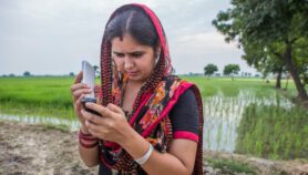
But in Kenya, attempts are under way to blend data collection with broader development goals, such as economic growth. Kenya’s economy is largely based on agriculture, forestry and livestock — economic activities that generally lead to high emissions and are also extremely vulnerable to the effects of climate change.
Last year, the Kenya Meteorological Department teamed up with Delft University of Technology in the Netherlands and Oregon State University in the United States to deploy a dense network of cheap, automated weather stations in the country as part of a wider project. Although still a pilot, the project’s ambitious goal is to place monitoring stations 30 kilometres apart throughout Sub-Saharan Africa.
“But with climate change, we don’t have two planets that we can look at, one with high carbon and one with low carbon, that’s where the models come in.”
Sarah O’Keefe, Environmental Change Institute, University of Oxford in the United Kingdom
Rolf Hut, a Delft University researcher working on the project, called TAHMO, says better weather data could leave low-income farmers better off. For example, it could help reduce micro-insurance premiums by enabling insurers to assess weather-related claims remotely.
“Farmers can insure their harvest, on a very small scale,” Hut says. “But, at the moment, companies have to verify impacts [in person] at the end of the season on a case-by-case basis, which makes their expenses, and eventually the premiums, much higher.”
With more-detailed weather data, insurance companies could simply check the records for each patch of land for which a claim is made, with the savings leading to cheaper premiums, he says.
To make this work, though, companies need independent, unbiased information, something the Kenyan system strives to provide. Insurers would pay for detailed data, while the basic data would be available to the public for free, according to the project plans.
Over time, the partnership aims to produce long-term data series that would also feed into local scientific efforts to better understand the country’s climate.
“As academics, we recognise how little data is available in Africa,” Hut says. “It’s one of the biggest and most complex land areas of the planet, but there are no ground observations.”
Kenyan model
The UN’s next major climate summit is providing a further push to improve weather data gathering. Ahead of the talks in Paris, France, this December, countries must submit voluntary plans for reducing carbon emissions from 2020. Some developing countries are working with international funders to develop ways to measure emissions and cuts.
For example, the philanthropic Clinton Foundation is helping build a system to pull together data from various sources and measure how much atmospheric carbon dioxide (CO2) Kenya produces. This System for Land-based Emissions Estimation in Kenya, or SLEEK, is meant to enable the Kenyan government to report more accurately on its efforts to reduce emissions.“Our model is able to estimate the amount of CO2 sucked up by a tree or by a forest, and how much of it would be released if that forest was cut down,” says Jackson Kimani, a regional director at the foundation’s Clinton Climate Initiative.
The system will integrate data about crops, soil, forestry and weather, making information accessible to governments and to people who may use it to better manage their activities. For example, farmers may be less interested in learning how much carbon dioxide their cattle and crops are emitting, but they can use information on soil quality to decide what to grow where, and what type of fertiliser is most useful on a specific patch of land, its supporters say.
As Africa’s economies grow, it becomes more and more vital to ensure that this growth is sustainable, and that progress made in achieving food security is not wiped out by extreme weather and climate change. Kimani says data gathering can be both a foundation for better science and a tool to monitor and support economic growth.
“Our first goal is to help the country monitor its emissions,” he says. “But we also want to use this system to meet its development needs.”
More on Data