By: Tharaka Gamage
Send to a friend
The details you provide on this page will not be used to send unsolicited email, and will not be sold to a 3rd party. See privacy policy.
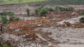
[COLOMBO] Poor flood forecasting facilities contributed to the damage caused by recent extensive floods in Sri Lanka, the worst in nine decades, scientists said.
Between 1 December 2010 and 12 January 2011, Sri Lanka’s northern and eastern districts received rainfall that almost equalled the area’s total monsoon rains from December to February each year, according to the Colombo-based Disaster Management Centre of Sri Lanka (DMCSL).
The unusually heavy rainfall caused the sudden floods that affected over 200,000 families, and damaged an estimated 6,000 houses, according to preliminary estimates.
"As a result of this heavy rain, more than 60 small tanks have been damaged, causing rapid spread of flood. We have to rebuild and repair the small-tank system of the country to manage the rainwater effectively," U.W.L Chandradasa, director of DMCSL, told SciDev.net.
"Sri Lanka does not have a proper [flood] forecasting system. This is an area to look into, probably, as part of preparedness," Herath Manthrithilake, head of the Colombo-based International Water Management Institute’s Sri Lanka programme, said.
DMCSL is preparing a risk reduction plan, and installing a facility to download real-time satellite pictures during emergencies like the recent floods.
So far, the country has had to take the help of neighbouring countries that downloaded satellite images and relayed them to Sri Lanka. This is time-consuming and less effective for immediate decision-making, Chandradasa said.
A study conducted by DMCSL, published two months before the floods struck, recommended the building of new reservoirs and tanks, repairing breached tanks and raising existing tank levels to increase water retention upstream.
The study identified several flood-prone areas in Batticaloa and Ampara districts. It attributed small-scale flooding to the blocking of canals and streams, especially in semi-urban and rural areas, through poor maintenance and encroachments.
DMCSL is taking action on the short-term recommendations with the help of department of irrigation. Already machinery and other equipment have been purchased.
More on Earth science