By: Lisbeth Fog
Send to a friend
The details you provide on this page will not be used to send unsolicited email, and will not be sold to a 3rd party. See privacy policy.
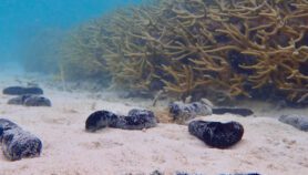
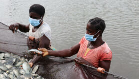
[BOGOTÁ] Poor countries could reconcile the soaring demand for fish with the need to safeguard biodiversity and make the fishing sector sustainable by harnessing a raft of new technologies, according to a report by the Food and Agriculture Organization (FAO).
The farming of fish and shellfish is the fastest-growing area of animal food production, accounting for almost half of the total supply of fish for food, says The State of World Fisheries and Aquaculture 2010, published last month (31 January).
And fish consumption is at an all-time high, said the report.
But, to ensure that wild fisheries and aquaculture continue to provide income for subsistence and small-scale fisheries — and protein for billions of people — poor countries need to embrace the internet, geographical information systems (GIS) and remote sensing, said the report. Technology has "reached the point of becoming an essential step in providing the enabling environment for the development of marine aquaculture".
The capacity to use GIS — computer hardware, software, data and personnel designed to collect, update and analyse geographically referenced information — takes up a chapter in the report.
Sensors can produce a wealth of data on temperature, the speed of the current, wave height and land and water use —whether they are on satellites, airborne devices, or the ground or are underwater.
"Spatial tools provide ways to obtain, organise, analyse and report objective and quantitative ways to allocate space among all users and stakeholders," said James McDaid Kapetsky, a specialist from the US-based consultancy company Consultants in Fisheries and Aquaculture Sciences and Technologies.
"The driver [for using these technologies] is fundamentally competition for space for fisheries and aquaculture."
The report said that GIS is already being used in developing countries, from Bangladesh to Cambodia and from Colombia to Malawi, to monitor aquaculture development.
"The software is not costly," said José Aguilar-Manjarrez, aquaculture officer at the fisheries and aquaculture department of the Italy-based FAO. "There are many GIS and remote sensing software packages at low cost, plus the new trend is open source [free] software."
But, he said, creating infrastructure, training personnel, and collecting, processing and maintaining data are expensive processes.
In addition, some developing countries have limited understanding of the principles and methodologies associated with spatial decision-making tools in marine science. And there is a need to strengthen collaboration and data-sharing between organisations.
John Selvaraj, specialist in fish resources management at Colombia National University, called for more training in GIS and remote sensing for undergraduate and graduate students.
The report cites Ecuador’s use of the Epidemic Alert and Aquaculture Management System for Shrimp Farming (SAEMA) to monitor shrimp health in the Gulf of Guayaquil. SAEMA uses data from the satellite Landsat 7, and various multimedia technologies, to measure factors such as the monthly rate of production in the estuary.
Another example is the Chilean Aquaculture Project, which offers daily information about sea surface temperature, clarity of sea water and the amount of chlorophyll a in the water. The latter, for example, enables fish farmers to take action when they know that harmful algal blooms have multiplied to a level where they threaten farmed fish.
In Colombia, the Marine and Coastal Research Institute (Invemar) is implementing a tool called Geovisor which will help fishermen locate shoals more efficiently using satellite information.
More on Biodiversity