Send to a friend
The details you provide on this page will not be used to send unsolicited email, and will not be sold to a 3rd party. See privacy policy.
The Organization of the Islamic Conference is reforming its science programme. But will change lead to better science? Wagdy Sawahel and Ehsan Masood report
"Together, we comprise one quarter of the world’s population; we hold 70 per cent of world’s energy resources, yet almost 86 per cent of predominantly Muslim countries are scientifically lagging."
This is the assessment of Tanveer Naim, former chair of Pakistan’s Council on Science and Technology and a consultant to the Organisation of the Islamic Conference (OIC), the intergovernmental grouping of predominantly Muslim states, whose secretariat is based in Jeddah, Saudi Arabia.
In November 2005 Naim completed a report, ‘Status of Scientific Research in OIC Member States’, assessing science and technology in the Muslim world between 1995 and 2005. One finding was that OIC states contributed just 2.5 per cent of articles in peer-reviewed journals during the survey period. Thirty-four OIC countries published ten papers a year or less.
Yet since that publication, the mood among politicians has firmly moved in favour of change.
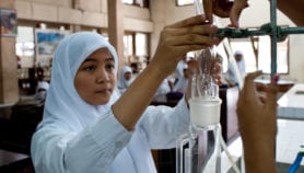
Reforming science in the Islamic world
A number of OIC states are beginning to invest more in research and innovation while at the same time overhauling their national scientific infrastructures. These states include the smaller Gulf states of Bahrain, Qatar and the United Arab Emirates. They also include medium-sized countries such as Malaysia, as well as OIC giants Egypt, Pakistan, Saudi Arabia and Turkey.
At the same time, reform of the OIC’s scientific institutions is also well underway. The reform programme is the most far-reaching since a concentrated burst of activity from 1979 to 1986. This eight year period saw the creation of three new OIC-affiliated scientific institutions: the Islamic Scientific, Educational and Cultural Organization (ISESCO) in Rabat, Morocco; the Standing Committee on Scientific and Technological Cooperation (COMSTECH) in Islamabad, Pakistan and the Islamic World Academy of Sciences, based in Amman, Jordan.
Five initiatives lie at the centre of the OIC’s science reforms, says Ali Salehi, Assistant Secretary General for science at the OIC secretariat.
The first is to meet the goals of a ten year strategy for OIC-wide science and innovation, approved in 2005 (see Islamic states urged to follow 10-year science plan). The programme of action includes encouraging collaboration between OIC states through an annual exposition of scientific and technological achievements and international competitions— including events specifically for women and expatriates. The creation of an OIC award for outstanding scientific achievement by scientists from OIC countries is another part of the strategy.
Second is the transformation of COMSTECH into a full member of the OIC family of institutions, and the promise of more funding for the committee from member states.
 |
| Credit: Patrice Cayré, IRD |
Third is a commitment to raising standards in the universities of OIC states. The initial target is for at least 20 universities to join the world’s top 500 — according to a 2007 ranking of world universities by China’s Shanghai Jiao Tong University, Egypt and Turkey are the only Muslim countries with universities ranked among the world’s best.
Fourth is to encourage OIC institutions to work more closely alongside existing international initiatives, such as achieving the Millennium Development Goals, or working alongside agencies such as the UN Environment Programme and the World Health Organization.
The fifth reform is to expand the scientific expertise inside the OIC secretariat. Related to this is a stronger science mandate for the Islamic Development Bank (IDB), the development funding institution for OIC member states, which is housed close to the OIC secretariat.
For example, one of the joint OIC-IDB new science funding streams is the US$250 million ‘Early Harvest Programme’. Launched with the backing of Malaysia and COMSTECH, the programme aims to provide funding for research that has the potential to advance economic development and reduce poverty, with immediate benefits. Says Rafee Yousuf, an advisor in the IDB’s Strategic Planning Office, "We want to consider projects that have social and economic impact in member countries… We want to be able to see results in one or two years."
Championing science in the OIC
Agreement to reform science in the OIC has come about in part because of surplus revenues from high oil prices.
Also critical has been the arrival of a number of reformist heads of state who see science and education as being fundamental to economic development, both in their individual countries, but also to the development of the OIC as a whole. They include Saudi Arabia’s King Abdullah Ibn Saud, Malaysian prime minister Abdullah Badawi, Turkey’s recently re-elected prime minister Tayyip Erdogan and Pakistan president Pervez Musharraf. Another important catalyst has been the the arrival of science-historian Ekmeleddin Ihsanoglu to the top job of secretary-general in the OIC secretariat.
Yet some disagreements still remain.
 |
| Credit: Nadia El-Awady |
One longstanding idea, championed by Musharraf and his minister of higher education, Atta ur Rahman, remains on ice. This is to create a pan-OIC fund for R&D. One of the fund’s aims, says COMSTECH’s assistant coordinator-general Muhammad Ali Mahesar, would be for some of the richer OIC nations to assist poorer members — 22 member states are in Sub-Saharan Africa — with research funding.
But despite three years of vigorous lobbying from Pakistan, the scheme has repeatedly failed to attract the support of Saudi Arabia — the OIC’s most influential state. According to one senior Saudi government official who asked not to be named, the OIC is a networking and enabling body. Funding R&D, he told SciDev.Net, should be the responsibility of individual member states.
Cooperation and collaboration
Whether the new reforms will help to improve science in the OIC remains an open question. Among those more sceptical is Farouk El Baz, director of the Center for Remote Sensing at Boston University in the United States, and a long-time observer of science in Arabic-speaking countries.
El Baz predicts that scientific indicators for some individual OIC countries will improve. But he is less certain about the prospect of increased OIC-wide scientific collaboration, or whether such collaboration will lead to better science, or more development.
History, El Baz says, does not support the thesis that good science is linked to scientists having a common religious identity. "During the height of Islamic civilization, masters of science were supported by visionary leaders, and included scholars from among Christians, Jews and other religions."
A different view is offered by Ahmed Abdullah Azad of Brac University, Dhaka, Bangladesh and a longstanding OIC science advisor. Azad believes that "a pan-Islamic science effort is necessary" if Muslim countries are serious about becoming scientifically and economically advanced.
"A small number of [wealthy] OIC member states can do it alone," he says. But the remaining poorer nations will need assistance, and for him that is what pan-Islamic cooperation is all about.
This article is part of a Spotlight on The way ahead for Islamic science.
More on Capacity building


Script media release
Journalists offered ‘big break’ mentoring opportunity from Radio Nigeria
03/04/19