By: Gilbert Nakweya
Send to a friend
The details you provide on this page will not be used to send unsolicited email, and will not be sold to a 3rd party. See privacy policy.
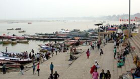
[NAIROBI] A project that will map groundwater resources in part of the drought-prone Horn of Africa region was launched in Nairobi, Kenya, last week (22 May).
It will use remote sensing technology to explore underground water to establish its quantity and quality, with the aim of exploiting the water in an emergency to combat drought and famine, and also to develop long-term resilience.
The project is an eight-month pilot coordinated by UNESCO but being implemented jointly with water ministries from Kenya, Ethiopia and Somalia, and has received US$1.55 million from Japan’s government for surveying Turkana, an arid area in northern Kenya.
It will contribute to the first phase of the regional Ground Water Resources Investigation for Drought Mitigation in Africa Programme (GRIDMAP), also a UNESCO initiative.
"GRIDMAP is a scientific consortium that aims to assess groundwater potential and build drought management capacities across the Horn of Africa and other parts of Africa," said Abou Amani, a senior water specialist with UNESCO.
Saud Amer, a water resource and remote sensing specialist with the US Geological Survey, a GRIDMAP partner, added: "The data will be used by governments and other agencies to address the water crisis that continues to afflict the region, and we will also look at factors such as rainfall, geology and geomorphology".
Casey Walther, GRIDMAP’s coordinator, told SciDev.Net that data collected from satellites will be validated by local experts through ‘ground truthing’ — relating image data to real features on land.
"We will train scientists in the technology needed to gain groundwater knowledge — they will be from central and local governments, NGOs [non-governmental organisations] and UN agencies dealing with humanitarian situations."
Walther said currently there is very little knowledge about groundwater resources in the region.
But it is estimated that Kenya and Ethiopia could each have up to 60 billion cubic metres of underground water, and Somalia up to 40 billion cubic metres.
The survey will use a satellite system called WATEX, which was used to locate water for Sudanese refugees in Chad in 2005.
John Nyaoro, Kenya’s director of water resources, said: "The project aims to mobilise scientific knowledge for policy setting and contribute to disaster preparedness."
Assessing knowledge and capacity in groundwater resources management will enable the drilling of emergency wells and help development planning.
The initial project’s full title is ‘Strengthening capacity to combat drought and famine in the Horn of Africa: tapping groundwater resources for emergency water supply’.
More on Water