By: Fatima Arkin
Send to a friend
The details you provide on this page will not be used to send unsolicited email, and will not be sold to a 3rd party. See privacy policy.
[MANILA] The 36th Asian Conference on Remote Sensing (ACRS) is under way this week (19-23 October), marking the second time that the Philippines has hosted the event and the first time since its membership to the Asian Association on Remote Sensing (AARS) was revoked in 2010.
“After the Philippines organised the conference in 1998, they had some generation change and the activities in remote sensing in the country went down for a while,” Kohei Cho, the general secretary of AARS, tells SciDev.Net. The AARS is the main organiser of the event.
“Now young people in the country have become quite active in the field and the Philippines rejoined ACRS,” Cho explains why the Philippines was reinstated as a member in 2012.
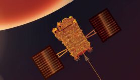
Remote sensing involves gathering information about areas or concerns from a distance, typically from an aircraft or satellite. Among its applications are in monitoring ocean and current systems, measuring ocean temperature and wave heights, mapping coastal features, land use and hazard assessments.
The theme of this year’s event is “fostering resilient growth in Asia”, which is reflected in the sub-plenary sessions that focus on resiliency, growth and development, and new satellite programs. The technical parallel sessions have a broader appeal, delving into everything from agriculture to energy.
Over 900 people have pre-registered from 29 countries, including all ten ASEAN member states. Cho estimates that roughly a third of them are students, a key group that conference organisers are actively targeting.
Several awards and competitions have been set up specifically for youth, such as the Japan Society of Photogrammetry and Remote Sensing award, which is given to a number of scientists under 35 years old who present the best papers or posters at the conference.
“To promote science, you need good young people,” says Cho. “Ideally, a student comes, gets an award and is hired by the university. Then he comes back to the conference and teaches other students.”
With climate change a key issue for countries that are extremely vulnerable to natural disasters, Cho says the conference is “a very good place to obtain information on the different types of research and programs being implemented in each country”.
Gay Perez, president of the Philippine Geosciences and Remote Sensing Society, which co-organised the event, tells SciDev.Net she hopes the display of interest in remote sensing from Filipino scientists will convince their national government to create the country’s first space agency. A road map is currently being developed with the aim of establishing one within the next decade.
“Currently, there is no single agency that can integrate all the programs and projects (on remote sensing in the country),” says Perez.
This article has been produced by SciDev.Net's South-East Asia & Pacific desk.
More on Technology