By: Catherine Brahic
Send to a friend
The details you provide on this page will not be used to send unsolicited email, and will not be sold to a 3rd party. See privacy policy.
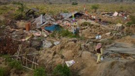
Indonesian islands are sitting on top of a section of the Earth’s crust that the 28 March earthquake has made vulnerable to future earthquakes, and to a tsunami, warn researchers.
The team led by John McCloskey, of the University of Ulster, United Kingdom, published their research in the latest issue of Nature.
Back in March, McCloskey and colleagues cautioned in Nature that the massive earthquake of 26 December 2004 had left the Sumatra-Andaman fault prone to another quake (see Tsunami quake ‘increased risk of further disasters’).
Nine days later, an earthquake measuring 8.7 on the Richter scale shook the region between the islands of Simeulue and Nias, killing about 2,000 people.
After calculating the geological stress in the region, including the shifts in pressure due to the 28 March earthquake, the researchers conclude that the greatest threat of another earthquake comes from the section of the Sunda trench — which runs parallel to Sumatra’s west coast — in the region of the Batu and Mentawai islands.
The Mentawai islands include from north to south: Siberut, Sipura and Pagai.
McCloskey’s team estimates that the last earthquake in the region of Siberut was in 1797. Further south, nearer to Sipura and Pagai, there were ruptures in 1797 and 1833, both of which caused large tsunamis.
The authors say that given this region’s history, a tsunami “could be a possibility” if there were another earthquake near the Mentawai islands.Click here to read the full Nature article
Reference: Nature 435, 756 (2005)
Read more about tsunamis in SciDev.Net’s Tsunami update.
More on Earth science